home | contents | previous | next | index
Chapter 31 - Blackchapel
[Blackchapel] was ... far to the East ... it involves crossing the range of mountains that lies beyond the Laughing River ... the peculiar landscape that might greet the traveler who emerges from the narrow Grinding Pass between Mount Horsehead, also called Hookjaw Mountain, and the Broken Mountain, which may also have other names, although these have not come down to us. In this place the traveler in his coach ... would find a gradually widening gorge or valley descending from the mountains in the place where a furious river had once run [herein live the] Nemites [and their neighbors] the ... Letites to the North and the ... Straves to the south
the House of the Dragon [had] dwellings not twenty leagues away, on the other side of the Broken Mountain ... the Broken Mountain has served ... to shunt large groups to one side or the other of the Nemite Valley, and both of its sides ... are guarded by [the Letites and Straves] ... the Valley is safe from the west, from the north and from the south ... to the east ... the valley is sealed off by a sheer cliff of granite ... nearly four thousand feet high, three miles wide, and running almost straight up. From its peak, it runs down to the east in a slope only slightly less sheer ... beyond "the Rise" ... is a land of bogs and mires [which] continues for several miles--all the way ... to Thundering Lake--or Lake Nivaper as some call it ... [Blackchapel is] directly opposite [the Thundering Lake] from the Rise.
Where in the East was [Morrolan raised]? There are--or, rather, were--a series of small kingdoms near Lake Nivaper, just south of the Hookjaw Mountains.
[Morrolan] came to [Blackchapel] traveling from the south ... his home was ... not twenty miles away.
[Morrolan has] the coinage of Esania (see pgs 6-7, Morrolan is from 20 miles to the south)
These passages establish the following:
- the Valley and Lake are both located near the Eastern Mountains
- the Valley starts 60 miles east of the Empire
- the Lake is "several miles" east of the Valley
- the Valley's east-west length is unknown
- the Grinding Pass is suitable for coach travel
- the Hookjaw Mountains are north of both the Valley and the Lake
- the Valley is large enough to support three different groups (the Nemites, the Letites and the Straves).
- Between the Valley and the Lake is described as "bogs and mires."
- The region to the immediate south of Blackchapel is known as Esania
The relationship between the Nemites, Letites and the Straves suggests the valley runs north/south, but the width of the Rise to the east is only 3 miles; that combined with the Broken Mountain forcing travelers north or south of the valley suggests a valley bounded by three peaks (one to the west, one to the northeast and one to the southeast, with the Rise being between the two eastern mountains).
I have identified three possible locations for the Nemite Valley and Blackchapel on Map of the East in Brokedown Palace:
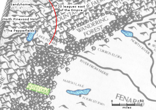
Eastern Lakes on the Map of the East in Brokedown Palace
Marsh Lake
In Release 2 of the Map of Dragaera, I ruled out the Marsh Lake as there are no mountains north or immediately west of it. In hindsight, "just south" on the scale of an entire continent could include the mountains north of the River From Faerie, but, even if we assume there are Dragaerans directly west of Marsh Lake, they are still over 100 miles away. Also, the Wandering Forest is between the Eastern Mountains and Marsh Lake, not "bogs and mires."
The North River Lake
In Release 2 of the Map of Dragaera, I thought Deathgate Falls and the Ash Mountains were on the east side of the Spearhead Channel, and used them as the northernmost/easternmost point of the Empire and concluded that this lake was Nivaper Lake. With Steve's Map showing the Falls and Mountains are actually west of the Channel, the northernmost point controlled by Dragaerans that I'm aware of is the North Pinewood Hold, and the easternmost is the Pepperfields, both of which are signficantly further from the North River Lake than I thought the Falls were.
Sotet Odu
A third candidate is Sotet Odu, which doesn't have an exact location on the Ace version of the Map of the East (it does on the Tor version, but I am doubtful that is correct, since there's no indication of a location there on the original map).
It means "Dark Hollow" according to Cracks and Shards, but google translate also suggests odu could mean lair, burrow, den or nest. None of these directly translate to "Blackchapel", but then again, this is the only reference to a "chapel" in all of the Text (the town, a road in the town named Chapel Road and the chapel itself for which the town is named); perhaps this was Paarfi's (or Steve's) attempt to translate the Eastern name to English-by-way-of-Dragaeran.
Regardless, no lake is shown near the label on either of the maps of the East, and the area all around Sotet Odu is described as "Wandering Forest" (not bogs or mires), so I don't think there's enough information to say Sotet Odu is Blackchapel.
It's also possible it's located south of the Map of the East altogether; the southernmost feature shown on the map is "The Great Marsh", and there is/was "a low, swampy field" north of Blackhapel:
Since we have last visited [Blackchapel] ... what had been a sort of low, swampy field north of the chapel had been drained ... and a series of low cottages had been built there
I was unable to locate Blackchapel with confidence, so I left all these locations off of the map in Release 3:
Blackchapel
Esania
The Grinding Pass
The Hookjaw Mountains
Mount Horsehead
The Nemite Valley
Lake Nivaper
The Rise
home | contents | previous | next | index
Questions? Comments? Please contact me at dragaera [at] bryann.net.
Copyright © 2020 Bryan Newell, unless otherwise noted.