home | contents | previous | next | index
Chapter 19 - Fornia
Kragar refers to Fornia as being Sethra's "neighbor":
I recognized the region at once because Dzur Mountain was marked near the left-hand border, and I recognized the Barnsnake River two-thirds of the way toward the right, which meant the markings on the right border were the foothills of the Eastern Mountains. Kragar pointed to an area a little above and to the right of Dzur Mountain. "Fornia County," he said, tracing an area that ran almost all the way to the edge of the map ... what do you know of Fornia? ... A neighbor of Sethra Lavode ... Fornia is old; over two thousand ... He did a fair bit of expanding before the Interregnum, and he's been at it again during the last hundred years or so ... he's been known to hire Eastern mercenaries ... From where in the East? / Not your part. Farther south, as I understand it.
I think the "Barnsnake River" is almost certainly an alternate name for the Yendi River. Here's what this area looks like on Steve's Map:
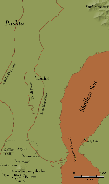
Dragon map
His claim that the Barnsnake river is two-thirds of the way across the map doesn't seem to line up with Steve's map, where the Yendi is almost directly north of Dzur Mountain.
Also, while he only mentions seeing the foothills of the Eastern Mountains on the map, he laters claims to remember one of the mountains from (presumably this same) map:
There were mountains before us now: the Eastern Mountains in general, and Mount Drift in particular; I remembered it from the map.
Based on South Mountain being the first peak you see when approaching from the southwest:
South Mountain is not the southernmost of the Eastern Mountains--Tiren's Peak has that distinction--but is, rather, a large mountain near the southern tail of the chain, and one that actually marks the westernmost extremity of the mountains. It achieved its name, in all probability, because it is the first mountain one will encounter when traveling from the southwest, or the last one will see when traveling from the northeast.
I think Mount Drift and South Mountain are one and the same.
How far do these foothills extend? No further than the Laughing River to the west, the Shallow Sea to the south, and Barleytown to the southwest:
South Mountain has ... quite vanished behind them, and they are making their way along the vast plain occasionally dotted with forests between the Shallow Sea and the Laughing River ... Near the end of the day, they found a small village called Barleytown, which is in the southern portion of the district called Agate... There was not much to this village--that is to say, it consisted of what had once been a posting station ... and a small inn ... the only one for fifty miles in any direction.
I concur with Alexx's assessment that Barleytown is about 270 miles from South Mountain.
The closest the Shallow Sea gets to the peak of South Mountain is about 325 miles, so I guessed that the 270 miles is from the base of South Mountain, not the peak. I think Barleytown is probably also a stopoff of the road that runs east of Dzur Mountain that multiple journeys appear to take place on.
I added foothills extending about halfway to these three bounding points:
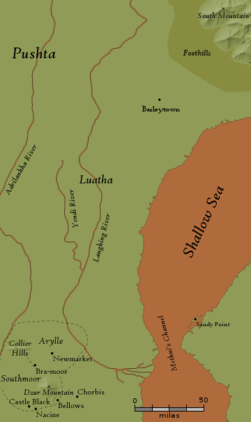
Barleytown and the foothills of the Eastern Mountains
In Release 2 of the Map of Dragaera, I thought Sethra's Army marched over 300 miles a day in the early part of their march (based on Vlad's claim that he'll see the Eastern Mountains after two days of marching). The distance between Castle Black and South Mountain (the closest Eastern Mountain) is actually greater on Steve's Map, so I at first thought this march was even more incredible (closer to 500 miles a day).
However, in a subsequent rereading of the book, I realized that I overlooked something; while Vlad is told he'll see the Eastern Mountains after only two days:
It had started raining a little before noon the very first day I'd marched with Cropper Company ... We'd been marching for about four hours ... Somewhere in there we crossed into enemy-held territory ... Years later I found out that Sethra had cut the entire army off from its supply lines ... The rainfall grew heavier ... We're bound for interesting country / I looked around; it was plain, and flat, with never a hill and hardly a tree to break up the terrain. .... we're moving toward a hilly area ... if we're reserves, I'd expect us to start heading north soon ... we're in the van, are we? Then, at a guess, we won't have more than a two-day march. Three, maybe, if the weather stays like this ... We put a few miles behind us, then stopped where we were on the road ... The grey clouds that had gathered beneath the orange-red overcast were gone, and in the distance there were now a few hills to be seen ... Thirty hours later ... You'll see the Eastern Mountains in the daylight ... I strained my eyes eastward, but in the failing light couldn't see any mountain ... We're pretty high up, Boss; I can tell you that much
It's actually more than that before he sees them. Shortly after the above exchange, they camp for the night, and Vlad's told a little about the plan for the next day's battle:
Their nearest outpost is three miles northeast of us ... We're still planning a withdrawal to the southeast?
That night, he does some light sabotage, and then the next morning, he fights his first battle, after which:
we fell back to the "fortified" position and stayed there for an entire day [and then] marched away ... due east, rather than the southeast that Sethra had originally planned ... the rains plagued us for the next day ... at the end of that day's march [they hold a funeral and then camp for the night] after a couple of days ... There were mountains before us now: the Eastern Mountains in general, and Mount Drift in particular; I remembered it from the map.
I count six days (one of which they appeared to not move, so five days of marching) in total before he sees the mountains.
From how far can you see a mountain?
This depends primarily on two things: the height of the mountain and the curvature of the planet (assuming viewing conditions like the weather are ideal).
Steve already told me the planet was "roughly" the same size as the Earth, so the only question is South Mountain's elevation.
About all that's said about it is that it's large. To determine what "large" means, I need to know what "average" means, and I was unable to find anything like an "average height of mountains" on Earth for the simple reason that there is no single agreed upon definition of what a mountain is.
I went through this wikipedia page that lists the tallest mountain in 84 different mountain ranges and found that they ranged from 9,281 feet (Mount Fogo in the Fogo mountain range) to 29,029 feet (Mount Everest in the Himalayas). I imagine most of these would be described as large (at least within their own range), so I decided to use their median height (about 13,000 feet) as an "average large mountain height."
Using this Distance to Horizon Calculator, I calculated that you could see a mountain that was 13,000 feet tall from about 140 miles.
That means in five days, Vlad traveled all but 140 miles of the 1,268 miles between Castle Black and South Mountain, which works out to be about 225 miles a day, which is still a lot, but Paarfi would not have been impressed:
The Briartown affair ... Eastmanswatch can move ... four hundred miles in a day and a night
Back to Vlad's march in Dragon:
There were mountains before us now: the Eastern Mountains in general, and Mount Drift in particular; I remembered it from the map. There was no more rain at all, as we had reached the dry lands west of the mountains; by whim of the Gods or freak of nature, the eastern slopes of the mountains were lush and forested while the western would have been desert were it not for the mountain streams, washes, and rivers that made their way across ... Eventually, late one evening, we reached the Eastern River ... Beyond it Mount Drift was getting close, and its companions were appearing tall and impassible ... once we crossed the river, we could follow it downstream right into the heart of Fornia's territory.
Vlad appears to travel north of South Mountain, but then heads back south and the battle ultimately takes place near the Wall and Baritt's Tomb:
we usually had the Eastern River on our left, and we always had the Eastern Mountains on our right, and we kept going north; and then one day we turned around for no apparent reason and headed back south, almost exactly retracing our steps ... one day, we made a sharp turn, put our backs to the river, and headed toward the mountains ... One peak in particular seemed to be our destination; a very tall, reddish-looking mountain with, it appeared, nothing whatsoever growing on its side. ... we stopped a few miles away from it, and I saw just how steep it was; it seemed to rise straight up from the ground, its top lost in the overcast [The Wall] ... That piece of rock is Baritt's Tomb.
There are other references to Baritt's Tomb that put it pretty far north:
[Baritt] had died only two years ago, and his monument [Baritt's Tomb], near Deathgate Falls, had been the site of the bloodiest battle since the Interregnum.
Baritt's Tomb was huge in every dimension ... It was stuck way out in the east, high up in the Eastern Mountains near a place where Dragaerans trade with Easterners for eastern red pepper ... [at the battle] Easterners were falling like ash from Mount Zerika.
But Morrolan assures Vlad that the Tomb is nowhere near Deathgate Falls:
We're near [Deathgate Falls]? No. But [Baritt's Tomb] will be here.
Vlad estimates the battle takes place about 300 miles north of the Shallow Sea (he says Khaavren's Sea, but I think that's another name for the Shallow Sea--regardless, Steve's Map makes it clear there is only one Sea near here):
I looked to the north, where I could see the camp of our reserves, stretching all the way from the stream to the Wall. Between us and the Wall, to the northeast, was a smaller hill--"Beggar's Hill," I learned ... We held the north ... To the west was the stream, a little spinoff from the Eastern River. It ran straight south until it emptied into Khaavren's Sea, some three hundred miles away. To the southwest were a couple of smaller hills ... three hundred miles is too far away to smell the sea
I think the Wall is to the southeast of South Mountain, since Vlad says it's to the northeast of the battle location. Since South Mountain is 300 miles from the Shallow Sea, I think the Wall is very near to it (the further south I put it, the more wrong Vlad's estimation of the distance becomes). I put it about 50 miles to the south of South Mountain based on my theory of mountain sizes.
The Flatstone River
The spinoff Vlad mentions is probably the same river Mica mentions:
Beneath those trees. There is a river on the other side of them. This river, whose name I do not know, is fed by various streams out of various of the mountains, but it runs as a brook for a considerable distance alongside of South Mountain, which I recall because I followed that brook for days and days [they rode] By this time ... they were riding due north, on the west bank of the stream to which Mica had referred, and with the South Mountain looming over them further to the east.
Vlad thinks the river branches off of the Laughing River, whereas Mica thinks it's formed by streams coming off the mountain; rivers don't normally split, so I think Mica is probably right.
I think we're even told the name of this little runoff. Earlier, when Sethra is planning the campaign, she mentions that they will end up in the vicinity of the Flatstone River:
[Sethra] pointed to a spot [on a map] and said, "We strike here ... and retreat this way, toward the Eastern Mountains ... We'll need to make arrangements [to bivouac] if we're west of the Flatstone River, or north of Turtle
I drew the Flatstone River starting north of South Mountain, flowing to the west near to the Lauhing River, then curving back to the south and hugging the Eastern Mountains to the Wall (where Vlad mentions it), and from there, straight south into the Shallow Sea.
home | contents | previous | next | index
Questions? Comments? Please contact me at dragaera [at] bryann.net.
Copyright © 2020 Bryan Newell, unless otherwise noted.