| The Map of Dragaera | |
| Chapter 1 - | Steve's Map |
| Chapter 2 - | Speculative Cartography |
| Chapter 3 - | The East |
| Chapter 4 - | The Grand Canal |
| Chapter 5 - | The Eastern River |
| Chapter 6 - | The Kanefthali Mountains |
| Chapter 7 - | Northport |
| Chapter 8 - | Harata |
| Chapter 9 - | Greenaere |
| Chapter 10 - | Elde Island |
| Chapter 11 - | The Southern Coast |
| Chapter 12 - | Daavya |
| Chapter 13 - | Arylle and Luatha |
| Chapter 14 - | Newmarket |
| Chapter 15 - | Whitemill/Gatehall |
| Chapter 16 - | Mistyvale County |
| Chapter 17 - | The Southeast |
| Chapter 18 - | Dragaera City |
| Chapter 19 - | Fornia |
| Chapter 20 - | The Collier Hills |
| Chapter 21 - | Castle Rock |
| Chapter 22 - | The Pepperfields |
| Chapter 23 - | Castle Redface |
| Chapter 24 - | Burz |
| Chapter 25 - | The Ash Mountains |
| Chapter 26 - | Daeld Mountains |
| Chapter 27 - | Kliuev |
| Chapter 28 - | Zerika's Point |
| Chapter 29 - | Miscellaneous Locations |
| Chapter 30 - | The Lay of the Land |
| Unresolved Issues | |
| Chapter 31 - | Blackchapel |
| Chapter 32 - | The Pepper Road |
| Chapter 33 - | The Massacre in Tirma |
| Chapter 34 - | The Holdfree Mines |
| Index | Questions? Comments? Please contact me at dragaera [at] bryann.net. Copyright © 2020 Bryan Newell, unless otherwise noted. |
home | contents | next | index
The Map of Dragaera
Hello, and welcome to the Map of Dragaera.
Herein I will explain how I created release 3 of the map of Dragaera, and catalog everything I think I know about the geography of Steven Brust's world of Dragaera. Even if you are not particularly interested in my reasoning, you may still find these documents useful as a compendium of what Steve has told us about the geography of Dragaera.
My goal with this project is to create the richest map I can that satisfies the text. While I prefer deduction, I will resort to speculation--and even guesswork--towards this end.
Although I've used the works of Steven Brust as a basis to create this map, this is my work, not his, and should you find any mistakes in this document, they should be directed to me, not him.
While this project is not official, Steve has been very helpful in its creation. He has clarified some text, identified some text that is in error, and even provided information not contained anywhere in the published text. I intend to use this latter information with the implied stipulation that he might well change his mind between now and a future publication.
Please beware that some of these articles may contain spoilers. While the subject matter I have chosen to cover is generally not central to the plot, it may pain you to read a passage attributed to Pel, for example, when his survival is in doubt in an earlier chapter.

All maps are oriented with north toward the top of the map, unless explicitly stated otherwise.
Map Resources |
|
| Distance Calculator | Calculate the direction, distance and average travel time between two points. |
| View/Download File | List of locations and their coordinates in CSV format. 1 unit = 1 mile. |
Prior Releases and Other Items of Dubious InterestClick on the thumbnails to view the full size images. |
|

|
Map of the Empire, Release 2 Originally released in June of 2011. |

|
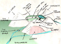
Sketch of the Pepperfields A sketch I made while trying to visualize the Pepperfields (not to scale). |

|
Map of the Empire, Release 1 Originally released in March of 2004. |
Acknowledgements
Maps of the Earth derived from Tom Patterson's Physical Map of the World
The Cartographer's Guild is an invaluable source of information, tips, and ideas about mapmaking
The maps themselves were created using a variety of software, including PaintShop Pro, GIMP, Wilbur, and Irfanview
Pan-and-zoomable map created with Leaflet, gdal2tiles-leaflet, commenthol/leaflet-rastercoords, muyao1987/Leaflet.LabelTextCollision (modified), makinacorpus/Leaflet.TextPath (modified), IvanSanchez's solution to keeping labels centered in the visible portion of regions, mourner/tinyqueue, mapbox/polylabel, aprilandjan/leaflet.measure (with the tweak suggested by Merion), stefanocudini/leaflet-search (modified), and mlevans/leaflet-hash.
Change Log
If at any point I have to make any major changes to the Map, I'll create a Release 4, but incidental changes will appear here.
3.3
- Added hash tool (location and zoom in the URL)
3.2
- Dragaera is the name of the planet, and it has two moons
- Fixed typo (Szanislo -> Szaniszlo)
- When point labels overlap, show the one that is mentioned the most in the text
- Fixed typo (Estonia -> Esania)
3.1
- Extended the Great Northwestern Road those last 8 miles to Ivaacim (thanks, Alexx)
- Added some missing index/wiki entries (thanks, Alexx)
- Fixed typo (Aeld -> Aelma)
- Added measure tool (click the icon on the left or hit 'm' on the keyboard to start, hit Esc to end the current measurement, or Esc twice to clear the measurements)
- Added search tool
3.0
- Initial release.
home | contents | next | index
Questions? Comments? Please contact me at dragaera [at] bryann.net.
Copyright © 2020 Bryan Newell, unless otherwise noted.