home | contents | previous | next | index
Chapter 36 - Other Missing Locations (B)
Bajfold County
the north part of Bajfold County, near the village of Keszpenz ... I went walking north. I walked and walked until I came to the biggest lake I'd ever seen. I tasted the water, and it tasted like salt ... So I walked back until I came into the mountains [where a hole fills up with water] [I] used its head to plow a big gap in the side of the hole so the water could get out. I plowed and plowed until I came to the plains ... I just kept going until I came to the far mountains, and I plowed right through them .... that is how the River first got started
My reading of this passage is that he walked north until he hit the North Sea, then walked south until he hit Lake Fenarr, then dug a hole in the side to release the River of Faerie, which flowed east until it hit the Grimwall Mountains, and thereupon dug out the Grimwall Pass.
Obviously not to be taken literally, but nonetheless it suggests Bajfold County is between Lake Fenarr and the North Sea, possibly in the open area to the north of the Grimwall Mountains, east of the Eastern Mountains.
Baritt's Valley
Presumably either near Adrilankha (where Baritt lived), near his tomb (which is near the Wall in the Eastern Mountains), or possibly some ancestral Baritt home.
[Kragar] poured each of us a glass of Baritt's Valley white.
Baritt had lived in a square, grey stone building on the outskirts of Adrilankha, in the hills to the west. He probably called it a castle. I could call my tunic a chair if I wanted to. It had three stories, a large front door, a couple of servants’ entrances, a few glass windows, and a sharply sloped roof. His estate struck me as too rocky, and the soil too sandy, to be good for much.
Before me stretched gentle, green hills; behind rose the cliff called the Wall, with the plain flat monument to Baritt, his "tomb" standing up before it; and around me were the Eastern Mountains
Bernen's Field
rebellion broke out along the coast to the southwest [of Dragaera City] in response to the combination of wheat shortages from the north [and] piracy from the Longburry Islands ... [Sethra put down the rebellion] on Bernen's Field.
Berrin's Creek
the gentle flow of Berrin's Creek
Blacktar
The County of Arylle was raised to a Duchy ... in recognition of Corpet's daughter ... who assisted in the Siege of Blacktar by refusing passage of supply trains through her domain, and, further, by refusing to sell her produce to the rebellious Baroness of Lockfree
Blackwater
North of Adrilankha.
[Paresh] had the rustic accent of the duchies to the immediate north of Adrilankha
[Paresh's family's] thirty acres ... our closest neighbor to the west [had] twenty-eight acres ... out neighbor to the north had thirty-five acres ... I was granted twenty acres a few miles south of where my family lived ... there was a woman I'd met in Blackwater who still lived at home.
[Paresh] heard sounds far to the south [of his home] ... I began to walk toward her keep--southward ... It was many miles, and all I saw around me as I walked were ... blackened woods ... I came to the place where I had been born and had lived most of my life ... when I had finished I continued my journey
Brambles
Numerous roads crisscross Mistyvale County: from Riverwall to Steps, from Brambles to Crossway, from Nacine to Gridley, from Hillcrest to Ripples, from Lottstown to Gorge.
Brambles Road
Numerous roads crisscross Mistyvale County: from Riverwall to Steps, from Brambles to Crossway, from Nacine to Gridley, from Hillcrest to Ripples, from Lottstown to Gorge. Moreover, these roads have not been carefully named; to be sure there is the Gridley Road, and the Lottstown Road, but there are three distinct roads called Hillcrest Pike and two that are known generally as the Brambles Road
Branch
the first seeds of the Great Plagues were beginning in Adrilankha, Candletown, Northport, Branch and Tirinsar
The first three locations can be found clockwise around the Empire. If this pattern holds, Branch is somewhere between Northport and Tirinsar. Its name suggests there are woodlands nearby, so it could be near Tree-by-the-Sea, or bordering the Great Woodlands, or even bordering the Twisted Forest further clockwise around the Empire.
Breaking River
like the floodwaters of the swollen Breaking River in spring
Bre'in
the mighty sculpture by the unknown artist called the Hammer of Bre’in (lost, alas, in the Fall of the City), to Rahera’s epic poem, Homecoming of Sitrata, to the nine-day play The Fall of Nileesitac
Briartown
The Briartown affair ... Eastmanswatch can move ... four hundred miles in a day and a night
Brickerstown
the retreat from Watcher's Lake [to] reach the safety of ... Brickerstown
Brightstone
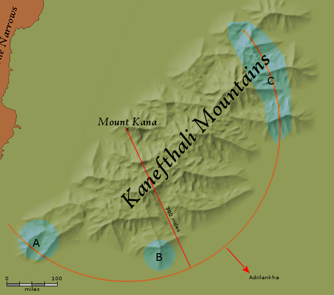
we cannot go to Adrilankha, for the simple reason that we have not secured it. And our ships that were intended to run between Hartre and Candletown are afraid of the reavers from Elde Island ... there is discontent in the rear areas. Indeed, there have been murmurings of revolt from Brightstone, not a hundred leagues from [Kana] ... As to Brightstone, well, so long as the murmurs remain murmurs, I am not worried. But, in any case, you have dispatched a brigade of Home Guard under Marchioness Wunra, have you not? That should be sufficient even if the reports be true.
I believe "rear area" means "between us and our objective, but closer to us." I drew a line from Mount Kana to Kana's objective (Adrilankha), and then marked off an arc 100 leagues (300 miles) towards Adrilankha, extending 90 degrees on either side of this imaginary line of attack.
Brightstone sounds to me like it might be found in mountains (or at least hills); looking at this arc, I think the three most likely locations are southwest of Mount Kana (A on the image below), southeast of Mount Kana (B) and northeast of Mount Kana (C):
Brightstone Possibilities
Unfortunately, I couldn't make a convicing case for any of these candidates, so I left Brightstone off of Release 3.
Brown River
Captain Gant-Aerethia ... from a marshy south-western lake region ... during the Island Wars, especially at the Battle of Near P'iensotta ... the Charge of the Brown River
Brownhead
a place that is very nearly at the western edge [of the Empire] ... to the far northwestern region of the continent, on a peak called Kana, in the Kanefthali Mountains. In the earliest days of the Empire, when the seventeen tribes ... began moving east, among the first discoveries was [the Kanefthali Mountains, and Zerika negotiated a portion away from the Serioli] This portion centered around four of the mountains: Koopyr, famous for its large twin peaks ... Needle-at-the-Top and Redground ... and Kana, which looked back north upon the others ... the Serioli [were] confined to the far north, on such peaks as Lostway and Brownhead ... in a lower valley of Kana called Whiteside, near a village of the same name
home | contents | previous | next | index
Questions? Comments? Please contact me at dragaera [at] bryann.net.
Copyright © 2020 Bryan Newell, unless otherwise noted.