The Map of Dragaera
Chapter 1 -Steve's Map
Chapter 2 -Speculative Cartography
Chapter 3 -The East
Chapter 4 -The Grand Canal
Chapter 5 -The Eastern River
Chapter 6 -The Kanefthali Mountains
Chapter 7 -Northport
Chapter 8 -Harata
Chapter 9 -Greenaere
Chapter 10 -Elde Island
Chapter 11 -The Southern Coast
Chapter 12 -Daavya
Chapter 13 -Arylle and Luatha
Chapter 14 -Newmarket
Chapter 15 -Whitemill/Gatehall
Chapter 16 -Mistyvale County
Chapter 17 -The Southeast
Chapter 18 -Dragaera City
Chapter 19 -Fornia
Chapter 20 -The Collier Hills
Chapter 21 -Castle Rock
Chapter 22 -The Pepperfields
Chapter 23 -Castle Redface
Chapter 24 -Burz
Chapter 25 -The Ash Mountains
Chapter 26 -Daeld Mountains
Chapter 27 -Kliuev
Chapter 28 -Zerika's Point
Chapter 29 -Miscellaneous Locations
Chapter 30 -The Lay of the Land
Unresolved Issues
Chapter 31 -Blackchapel
Chapter 32 -The Pepper Road
Chapter 33 -The Massacre in Tirma
Chapter 34 -The Holdfree Mines
Chapter 35 -Other Missing Locations (A)
Chapter 36 -Other Missing Locations (B)
Chapter 37 -Other Missing Locations (C)
Chapter 38 -Other Missing Locations (D)
Chapter 39 -Other Missing Locations (E)
Chapter 40 -Other Missing Locations (F)
Chapter 41 -Other Missing Locations (G)
Chapter 42 -Other Missing Locations (H)
Chapter 43 -Other Missing Locations (I)
Chapter 44 -Other Missing Locations (J)
Chapter 45 -Other Missing Locations (K)
Chapter 46 -Other Missing Locations (L)
Chapter 47 -Other Missing Locations (M)
Chapter 48 -Other Missing Locations (N)
Chapter 49 -Other Missing Locations (P)
Chapter 50 -Other Missing Locations (R)
Chapter 51 -Other Missing Locations (S)
Chapter 52 -Other Missing Locations (T)
Chapter 53 -Other Missing Locations (V)
Chapter 54 -Other Missing Locations (W)
Chapter 55 -Other Missing Locations (Y)
Chapter 56 -Other Missing Locations (Z)
Index

Questions? Comments? Please contact me at dragaera [at] bryann.net.

Copyright © 2020 Bryan Newell, unless otherwise noted.

previous | next

home | contents | previous | next | index


Chapter 1 - Steve's Map

The first two releases were based primarily on the text, but also (in the case of the last release) on email correspondence with Steve.

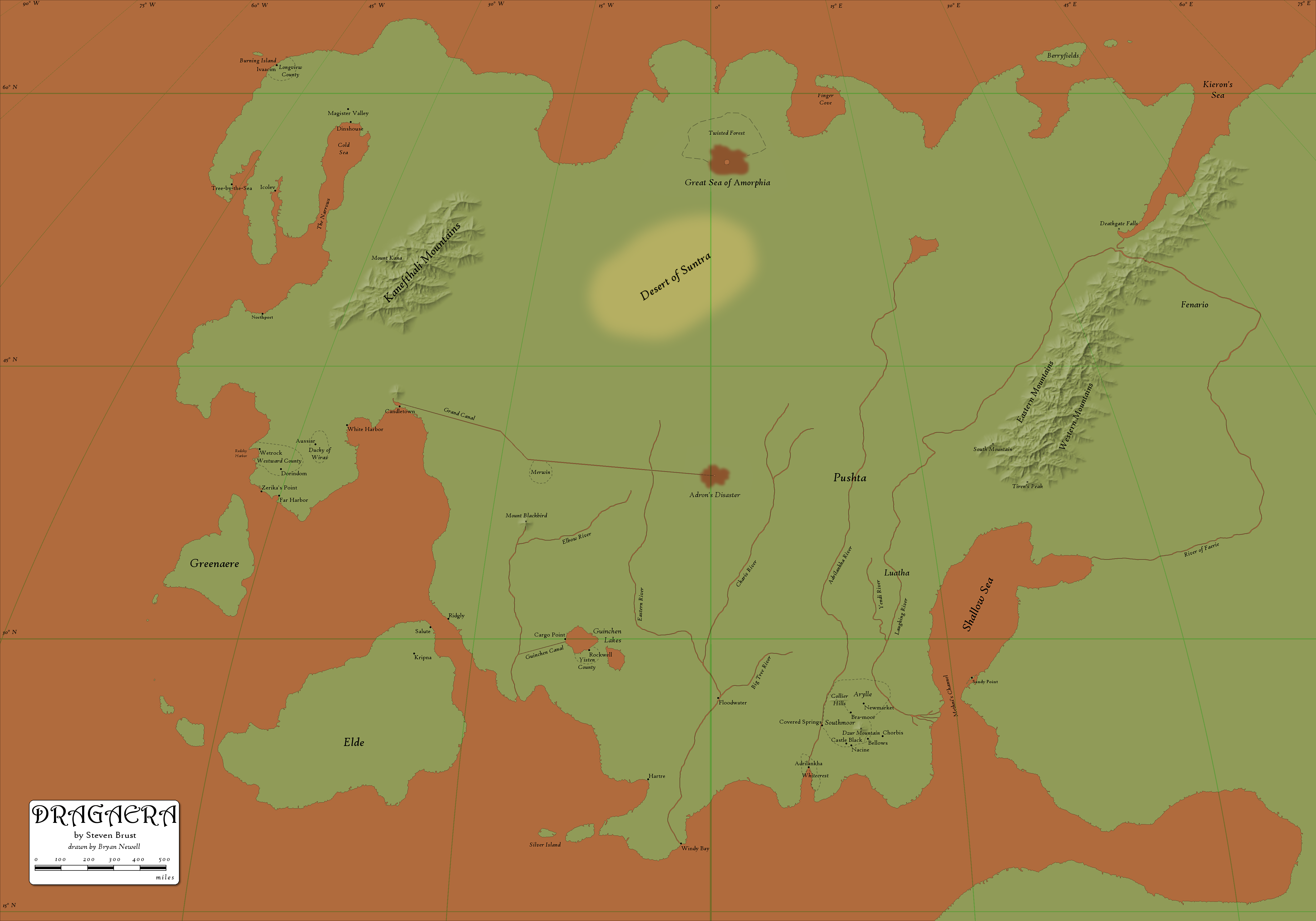
This release was prompted by Steve's decision to share photos of his maps with me while he was working on The Baron of Magister Valley. I took those photos, resized them to the scale I'm using here (1 pixel = 1 mile), and merged them all into a single image.

That map was further tweaked after conversation with Steve (especially for the new areas introduced in The Baron of Magister Valley, but also for both Seas of Chaos and the Shallow Sea).

The map below is the final map I produced for Steve. I will hereafter refer to this as "Steve's Map", and it is the basis for much of the work herein.

@stevesmap
(click on the image above (or here) to view a larger version)

Please note that the coloring of the water and land is taken directly from the photos Steve shared with me; that is, this is how his map was colored.


In the last release (and even on the version of the map I made for Steve above), I pretended that I could draw lines of longitude on the map. Longitude converges on the north pole, so the further north you go, the closer lines of longitude become.

I realized a major flaw in this: I was still using "straight up" as North when it came to translating the text into points on the map.

I attempted to create release 3 with north following those lines of longitude, but ultimately I was not satisfied by the result, so for release 3, I have dropped longitude from my map.


previous | next

home | contents | previous | next | index

Questions? Comments? Please contact me at dragaera [at] bryann.net.

Copyright © 2020 Bryan Newell, unless otherwise noted.