home | contents | previous | next | index
Chapter 4 - The Grand Canal
to barges that would make their way along the Grand Canal from Candletown to Dragaera City.
Since the Grand Canal appears to connect Dragaera City to the western coast, my assumption is that the flow (insomuch as a canal can flow) of water in the canal is westward.
However, Steve told me that the Lesser Sea of Chaos is drawing water into itself via the Canal in Vlad's time:
the Grand Canal runs from Candletown to the old Dragaera City (i.e., it now runs into the lesser sea of Amorphia)
The Grand Canal runs through the county of Merwin, home to Loraan:
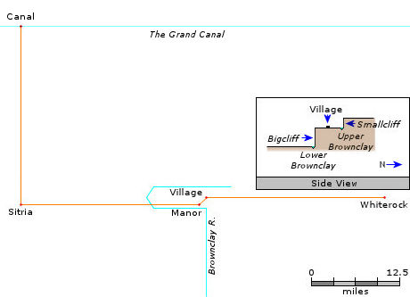
The place to which we now direct our reader is in the county of Merwin, along the Grand Canal--or as near to the geographical middle of the Empire as anywhere one could name. In the northwestern corner of this county, actually touching the canal, is a barony, called Loraan ... since the canal was built. The only significance of this barony ... had been the difficulty ... of cutting the canal through the solid rock of the district. It had required the combined effort of the Imperial engineers and the baron himself ... to dig the canal ... He had first intended to name the place Redrock, because the rock was, in fact, of a reddish color; but a distant cousin of his was already lord of a county far to the east called Redrocks; so, to avoid confusion, he named his home Sitria ... [Kana] is far to the west, in the mountains ... journey of hundreds of leagues merely to see [Loraan] ... Canal, a near-by village
Steve's Map has a dotted line indicating the borders of Merwin, but no locations within it are labeled.
In Athyra, Vlad visits a small village in this Barony, which is located about 1.5 miles south of a cliff referred to as Smallcliff.
The Master lived under the shadow of Smallcliff along the Upper Brownclay River, which was half a league from the village
Smallcliff is to the north, we live below Smallcliff
To the west of this village, about 3 miles or so, is a place in the road referred to as the Curving Stone, which appears to be very near to Loraan's manor house.
soon they were walking along the Manor Road west of town
Savn stood at the Curving Stone for a long time, staring down the road that led to the door of [Loraan]'s manor house, which was itself out of sight behind a curve in the road ... He walked on the road as if he belonged there [like] a visiting noble, although he had heard that these people teleported instead of walking, even when they only needed to go ten or twenty miles. The manor house came into sight ... [Rocza] recognized the large rock [Curving Stone?], the nearby house [Manor House?] and the winding, twisting road
Although its direction is never stated precisely, I believe there is another cliff to the south, named Bigcliff.
it's about half a league to Bigcliff, and then halfway down the slip and along the path ... Savn at once abandoned the road in order to cut directly toward the hills above Bigcliff ... The river flats. That's where the people from Brownclay and Bigcliff go to bathe and wash clothes. / Ah, yes. I was there earlier; I hadn't realized we were in the same place. This must be Bigcliff, then.
Vlad stood, staring out at the river flats so far below them, dotted with people bathing, washing clothes, or just talking. Savn tried to view the scene as if it were new; the river rushing in from the right, turning sharply around the Black Rocks ... then suddenly widening into the flats ... then narrowing gradually once more as it cut down into the plains and began turning south, toward the sea, many impossible hundreds of miles away ... They continued watching the River Flats.
Since the river comes in from the right, and then turns south, Savn is facing south, which puts the Brownclay River to the west.
That would put Loraan's keep (Sitria) to the west as well:
it was at Loraan's keep rather than his manor house. The keep, if I recall the landscape correctly, must be on the other side of the Brownclay ... he just came to stay at his manor house, a league or so from town, near the place I first saw you.
To the east about half a day (25 miles, I'll guess), is the town of Whiterock
As they set off along the Manor Road ... [Linseed oil] must have been what they served the last place I ate, too, half a day east of here. / That would be Whiterock ... they came to the last hill before Tem's house
which appears to be located in a different county
someone else is lord over Whiterock, though. A Dzurlord. We hear stories about him ... you have to work his fields ... Vlad continued to stare down at the River Flats.
I guessed that Sitria is located about the same distance to the west of the village.
Finally, in the very first passage above, Paarfi refers to the nearby village of Canal, which, based on its name, I assumed was located directly adjacent to the Canal. I guessed it was a similar distance due north of Sitria.
Barony of Loraan
On the photos of Steve's Map, there is an unlabeled point in the far northwest of the region labeled as Merwin that lines up almost exactly with where I would expect Sitria to be based on the above, so I located Sitria there, the nearby city of Canal due north and directly on the Grand Canal.
This resulted in Whiterock appearing slightly within the area Steve had labeled as Merwin, so I pushed it a little bit further east until it was outside of Merwin.
Savn believes that the Brownclay River runs south all the way to the ocean. Steve shows Merwin almost directly north of Mount Blackbird, so I drew the Brownclay River flowing south into the Elbow River.
home | contents | previous | next | index
Questions? Comments? Please contact me at dragaera [at] bryann.net.
Copyright © 2020 Bryan Newell, unless otherwise noted.