home | contents | previous | next | index
Chapter 25 - The Ash Mountains
When Zerika et al travel from Dzur Mountain to Deathgate Falls, Sethra describes the journey thusly:
[Dzur Mountain is] about midway between the Adrilankha River and the Eastern River. Either would be suitable for a southward journey, but ... you will be going north ... there is a road through the jungle ... that crosses the Eastern River ... at a good ford. The road then turns east to the Shallow Sea, but if you continue north [you will] find a road running through the jungle [to] Wilder [on] the edge of the Pushta [from there go] North and a little east ... cat-centaurs near here ... continue northward ... to the mountains ... you will be skirting the Eastern Mountains ... pick up the Eastern River [again, keep it upon] your left hand until ... you will cross it once more ... near the lower slopes of Mount Klassor, which is heavily forested ... cross the Eastern River [again] ... only a score of miles from there [to] the feet of the Ash Mountains [continue and] ascend until you meet the Blood River, which you follow into Greymist Valley, thus, to Deathgate Falls.
Past Wilder, they appear to cross the Laughing River twice more. Since they're east of the river at Wilder, that would leave them on the east side after the 2nd crossing. Their ultimate destination is Deathgate Falls, which is marked on Steve's Map, and is west (and north) of the Laughing River. In the full passage I'm quoting from, Sethra switches maps between these two crossings, and I'm going to guess that it's the same crossing, just pointed out on two separate maps.
As to where this crossing takes place, Pel supplies a clue:
A large tribe of Easterners has crossed the mountain ... several hundred at least ... They have come ... from the passes of Mount Bli'aard .. the Easterners spoke of a band of humans they passed [Zerika] ... Mount Bli'aard is five hundred leagues from here, if it's a mile! ... They have gone to Mount Bli'aard? Toward Redface, perhaps ... They have not gone to Mount Bli'aard ... but north of Mount Bli'aard.
Since we know where Mount Bli'aard is, this final crossing must be near the northernmost extent of the Laughing River.
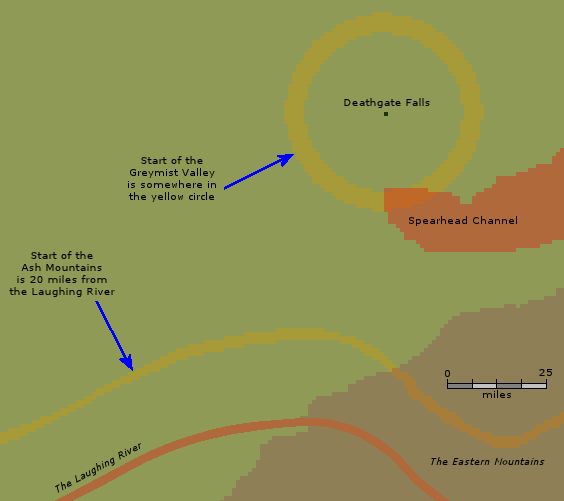
Sethra makes the journey after this crossing sounds like a straight shot, which suggests the Greymist Valley runs north/south. However, on Steve's Map, the southern tip of the Spearhead Channel curves back to the west.
Since the Greymist Valley is 20 to 25 miles long, the Spearhead Channel is actually closer to the Falls than the start of the Valley.
The Valley is described as being half a league high (1.5 miles, or about 8,000 feet):
Nearly a full year after setting off on their mission, Piro [said] How high up are we? ... It feels to be the same height as North Pinewood Hold, which has been measured as nearly half a league higher than the sea [and] is a thousand miles from the sea ... If Sethra's maps continue to be as true as they have been, then we are going no higher ... we should soon run into the Blood River, which we will follow into the Greymist Valley. And, as we will be following a river, well, you perceive we must therefore go down.
The above limits where the Ash Mountains can be in three ways:
- The Valley is 20-25 miles long, with the Falls at one end
- The Ash Mountains start 20 miles from the Laughing River
- The Spearhead Channel limits where the mountains can be
Ash Mountain Limitations
Paarfi refers to the Blood River (which runs down the middle of the Greymist Valley) as having a west bank:
[Piro and] friends were positioned, at this time, on the west bank of the Blood River.
This establishes that the river runs north/south to at least some degree. It can't run directly north south, or the valley would start in the Spearhead Channel. I also think it's very unlikely that they traveled all the way north of the Falls and then came back south to it, so that limits it to running southwest to northeast.
Paarfi says the Ash Mountains consists of three peaks, and these three peaks appear to border the Greymist Valley.
The Greymist Valley itself stretches some twenty or twenty-five miles, beginning next to Hanging Mountain, and continuing past the next of the three peaks that, still part of the Eastern Mountains, are together called the Ash Mountains. This next mountain is called Gyffer's Peak, and it, of the three, is the one beside which the greatest channel has been cut by the fast-flowing Blood River ... dark mountains looming above on both sides, the snowy caps of Gyffer's Peak behind, and the soft green of Round Mountain before. Gyffer's Peak ... is even populated upon some of its lower slopes, though not ... in the valley itself... there are several villages on the west side where coffee beans are grown [and] often brought overland to the Eastern River or to the Spearhead Channel and thus to the Kieron's Sea ... They discovered as they rode that ... they had, in fact, left Gyffer's Peak, and were now on Round Mountain. The Blood River, once more flowing on their right, was slower and wider, as if gathering itself for the great plunge that it knew was coming.
From south to north, we have Hanging Mountain, Gyffer's Peak and Round Mountain. Paarfi tells us no one lives in the Valley itself, and yet all three mountains appear to be populated (the passage above mentions that Gyffer's Peak is populated by coffee bean growers on its lower slopes).
Hanging Mountain has a village named Trader's Rock on its western slopes:
we left [Pel] in a small village on the southern slopes of Dzur Mountain, we now find him just outside a small village, this one called Trader's Rock, on the western slopes of Hanging Mountain.
And people live on Round Mountain's lower slopes:
[Tsira/Grassfog's family] lived in the far north of this range, in the Round Mountain ... Deathgate Falls! [They] lived lower on the slopes ... not far, as distances go, from the Blood River
As they're passing Gyffer's Peak, Paarfi says mountains loom over them "on both sides." He also seems to believe that these three mountains are "together" the Ash Mountains, which suggests there are no other mountains nearby.
There's a little more information when Vlad and Morrolan make a similar journey:
Morrolan had said the the journey should only take a few days, as we would teleport to a point fairly close to Deathgate Falls ... The first thing I noticed was the sky. It was still the ugly reddish, orangish thing that hangs over the Empire, but it was higher and somehow cleaner. We were surrounded by by grasses that reached my waist. There was not a tree or a mountain or a building in sight
We rested under the open sky that night ... we resumed our walk. It was a nice warm day, and I saw the distant peaks of mountains [their destination].
[Morrolan and Vlad] set off for the mountains. After walking a few more hours, Morrolan stopped again and stared straight ahead, toward the base of the mountains. He said, "I think I can make out enough details to teleport us safely." [they teleport] The air here was cool, and very biting. Behind us was an incredible expanse of green. All around us were mountains, hard and rocky.
We continued up the slope for another couple of hours, then it leveled off ... After another hour or so, we came to a wide, fast stream coming up a slope we didn't take. Morrolan turned with the stream, and in a couple more hours it had become a small river. By dark it was a big river ... Blood River ... After walking for an hour or so the next morning, we had followed it to Deathgate Falls.
Deathgate Falls has an exact geographical location; therefore, so do the Paths of the Dead, only they don't ... I know that somewhere in the Ash Mountains is a very high cleft called Greymist Valley ... the Blood River flows into the valley, and over a waterfall, and [into the Paths of the Dead] ... The height of the waterfall has been reported [to be] a mere fifty feet, a thousand feet, and any number of distances in between. ... No one has ever come to the foot of the falls by any route except the cliff, though many, especially Hawks and Athyra, have tried. For all intents and purposes, the foot of the falls isn't in the same world as the lip.
I stood next to the lip of [Deathgate Falls] and looked out at an orangish horizon interrupted by the occasional jutting of rocky peaks. Below me grey fogs swirled and rose, obscuring the bottom hundreds of feet below ... The Blood River somehow turned white on its thundering way down.
I think Vlad's observation that the only way to get to the base of the Falls is over the cliff is interesting. It could be magic, of course, or perhaps something more mundane, like the Falls are formed when the Blood River flows into a hole/cave (something like the Fell Brook flowing into the Gaping Gill, only much larger).
I also think it's interesting that while looking over the falls, Vlad says he can see "the occasional jutting of rocky peaks." This suggests there is more to the Ash Mountains than just the three Paarfi mentioned.
Trader's Rock's location on the western slopes of Hanging Mountain puts it on the western side of the Valley.
And Paarfi says,
They discovered as they rode that ... they had, in fact, left Gyffer's Peak, and were now on Round Mountain. The Blood River, once more flowing on their right, was slower and wider, as if gathering itself for the great plunge that it knew was coming.
Since the Blood River is on their right, they are on the western side of it, and have transitioned from Gyffer's Peak to Round Mountain, putting both of those mountains on the western side of the Valley as well. That means all three are on the western side, and something else makes up the eastern side of the Valley. My guess is that it's a relatively even ridge without much in the way of peaks.
I drew Hanging Mountain's southern slopes extending to a point 20 miles north of the Laughing River, and then guessed that Mount Klassor was about 30 miles from that point into the area on Steve's Map marked as the Eastern Mountains:
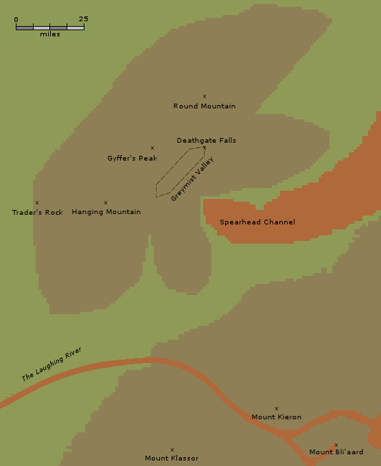
Mount Klassor
home | contents | previous | next | index
Questions? Comments? Please contact me at dragaera [at] bryann.net.
Copyright © 2020 Bryan Newell, unless otherwise noted.