home | contents | previous | next | index
Chapter 22 - The Pepperfields
Far to the east of Dragaera City, across the Pushta, lies the domain of Pepperfield:
Pepperfield is a far eastern fief ... make it clear as the Threefalls River; the fief lies in a small valley, between two impassible mountains, on the eastern border of the Empire.
The domain of Pepperfield, a large, fertile plateau nestled between Mount Kieron and the Ironwall... On the northern side there is a sheer wall some five hundred feet high, upon which is built the Looming Fortress ... and behind it the North Pinewood Hold ... there is a steep, winding path from the fortress down to the plateau ... The Looming Fortress ... is inaccessible except through the Pepperfields themselves. Another entrance is from the east, where a long, gentle slope rises from a gap in the Ironwall some four leagues to the north. Still another approach is from the southeast, a steep climb, unsuitable for horses ... The final approach, that of the south-west, ... was to follow a narrow but well-trodden path up from the valley of the Eastern River, only a few leagues below its source at the Thundering Falls in the Ironwall. To reach [the fastest route to Redface from the Pepperfields] you must only follow this brook, which is called the Slipknot, and flows over the ridge very near [Nilk'arf's Tower] ...
Miklos travels through this area in Brokedown Palace as well:
the low rocks at the lake's edge ... Miklos stood on a shelf of flat, grayish rock. Mountains rose behind him and on either side, some of them showing faint white cappings. Before him, as far as he could see, was a lake, also gray but with a blue tint. The lake covered nearly all of the mesa on which he stood, save for an unscalable mountain wall to the near side. On the other side, the north, he could see nothing but water. The breeze came from off the lake, chilly yet bracing ... [he] scooped up a handful of the water of Lake Fenarr ... It was more than two years ago that he had passed this way traveling west. Then, he had known it as the source of the River. Now he knew it for the basin that collected water from higher mountains, and sent it forth both east and west. In the west, the Lake's spawn was called the Eastern River.
I believe that Lake Fenarr is at a higher elevation than the Pepperfields, the Ironwall is the cliff-face between them, and that the Thundering Falls are the point at which the Laughing River flows over this cliff face.
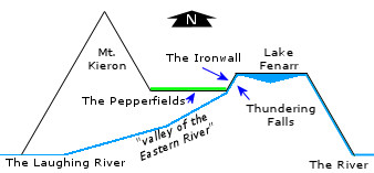
Cross-section of the Eastern Mountains (not to scale)
From the Pepperfields, it appears there is another cliff face to the north, upon which is located the Looming Fortress and beyond is the North Pinewood Hold. The valley of the Laughing River is to the southwest, and Castle Redface (and Mount Bli'aard) is to the southeast.
From Castle Redface, the layout is as described here:
To the south there is the Redface itself, a drop of more than [2000] feet into the Eastern River. To the west, there is the ... gentle slope of Mount Bli'aard leading down to the nearest city, that being Troe, or what was then called Bengloarafurd. To the north the mountain rises ... leading off to Mount Kieron, and, further, to the high plateau of Pepperfield, before dropping to the Valley of Salt, beyond which lies the region of Sandyhome. To the east there are the distant peaks of the Ironwall and Whitecrown which lead to the lands of the Easterners.
So, very roughly, the area appears to look something like this:
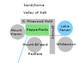
Rough Map of the Pepperfields (not to scale)
Unfortunately, the only measurements given between any of these places do not appear to be useful:
Sandyhome ... is hardly fifty leagues [from Pepperfields] ... we are bound for Redface, less than fifty leagues from Pepperfields. / Fifty leagues of the city, or fifty leagues by the Easterner's reckoning? / A day's brisk march by the footpaths ... or else two days' quick ride by the horse-paths.
Fifty leagues is presumably 150 miles, unless the measurement is, as suggested, by the Easterner's reckoning (in which case the measurement is meaningless, as there is no description given of how many miles that might be), but this is almost certainly not the case, as 150 miles north of the Laughing River would put Sandyhome in the middle of the Spearhead Channel on Steve's Map.
About the only piece of information we can be relatively certain of is that, since both measurements are given as 50 leagues, and in the same general passage, the Pepperfields are presumably exactly midway between Redface and Sandyhome.
Since all these places border each other, but not much in the way of actionable distances are given, and they're located within a mountain range, I decided to map out this area with the assistance of a hex map.
I made each hex be 25 miles across, positioned so that the Laughing River mostly flowed along edges. You can think of each hex as being analogous to an individual mountain or peak within the range.
I then located these places as follows;
I put Whitecrown in the center of the hex south of Lake Fenarr, Mount Bli'aard in the center of the hex west (and a little south) of Lake Fenarr, and Mount Kieron in the hex west (and a little north) of Mount Bli'aard.
In the hex north of Mount Bli'aard, I put the Pepperfields about 1/3rd of the way up the hex north, the North Pinewood Hold 2/3rds of the way north, and the Valley of Salt along the border between that northern hex and the hex to the north of it.
That hex (the one just north of the Valley) represents the downward slope of the Eastern Mountains, and ends very near to the Spearhead Channel; I put Sandyhome in the center of that hex, and my guess is that it gets its name because it is near to the coast.
I put Castle Redface just north of the southern edge of the hex that I believe represents Mount Bli'aard.
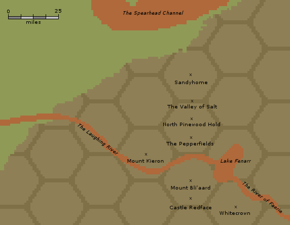
The Pepperfields, visualized on a 25 mile hex grid
That results in the Pepperfields being almost exactly between Castle Redface and Sandyhome (about 30 miles from each of them).
I believe Castle Redface is located in the County of Korio based on this passage:
instead of taking this road, turn rather to the north ... Lord Adron's domain extends further to the north than it does in any other direction ... Pepperfield lies to the north, and the southern tip of the domain touches directly on the County of Korio, the northernmost of Lord Adron's domains.
In the Duchy of Eastmanswatch:
All the lands around Lake Szurke, within the Duchy of Eastmanswatch ... [Vlad] shall be known as Count Szurke.
Miska
Vlad is given a county near to the Pepperfields:
All the lands around Lake Szurke, within the Duchy of Eastmanswatch ... [Vlad] shall be known as Count Szurke.
All you have to do is go to Lake Szurke and live in the manor, or castle, or whatever it is ... It is just west of Pepperfields, which is in the mountains west of Fenario, so you will be close to our homeland.
My grandfather no longer lived [in Adrilankha]; now he lived in a manor house just outside of the town of Miska, near Lake Szurke.
I located Miska midway between the Pepperfields and Mount Kieron.
home | contents | previous | next | index
Questions? Comments? Please contact me at dragaera [at] bryann.net.
Copyright © 2020 Bryan Newell, unless otherwise noted.