home | contents | previous | next | index
Chapter 2 - Speculative Cartography
My general strategy has been to deduce what I could, and then speculate from there, and guess only as a last resort.
To a degree, this is a fool's errand; the very act of trusting what Steve has to say about Dragaera is speculative on my part due to his use of unreliable narrators. Nonetheless, I have attempted to take what he writes (and the map that he shared with me) at face value as much as possible.
A word about attributions:
When I quote from one of Steve's books, it will look like this:
Above the doorway was a particularly detailed sign in which an Athyra was flying over a map of the Empire.
I have refrained from using page numbers, and have instead opted for chapters. I've gone through multiple editions of Steve's books, and the page numbers proved unreliable.
When I quote a person (usually Steven Brust himself, as in this example), the speaker should be made clear in the text around the quote, which will look like this:
Vlad is a lousy geographer.
Sometimes I'll show the relationship between two points like this:
| From | To | Go | Miles | Leagues | Time |
| Adrilankha | Dzur Mountain | Northeast | 247 | 82 | 4 days and 17 hours |
These observations are always from my map, never the text, and are measured as the jhereg flies (assuming they fly in straight lines).
What I mean by "leagues" and "time" will be explained shortly.
The Planet
I believe Dragaera is the name of the planet based on this passage:
Morrolan would be the last person on Dragaera to deliberately let his home be used by a Jhereg on the run.
I asked Steve how big the planet is, and he replied,
I use "roughly Earth" for convenience.
It orbits its parent star every 17 months, each of which is 17 days in length, for a total year length of 289 days:
The days became weeks ... and these weeks, likewise, turned themselves into months of seventeen days
Why are there seventeen months in the Dragaeran year?
Each day is 30 hours in length.
thirty hours, or a full day and night.
This means there are approximately 8,670 hours in a Dragaeran year, and 8,766 hours in an Earth year.
It appears to have two moons, named Bigmoon and Littlemoon:
Above me, Morning Snake would soon slither off until nightfall, but watched over us for now, if you believe in that sort of thing. Bigmoon was high up, but already becoming pale as the light grew; Littlemoon wouldn�t rise for another nine days.
Geographical Zones
While I have decided to avoid longitude in this version of the map, I think lines of latitude are still possible (since lines of latitudes are evenly spaced as you go north or south, unlike lines of longitude, which converge on the poles).
The continent upon which the Empire is located is located in the northern hemisphere:
This is a funny part of the world ... The landscape, I mean. Maybe it's because we're so far north of the equator, or because the Kanefthali Mountains start only a few hundred miles away
I have heard ... that among Orca who take long voyages to the south, such as trading expeditions to Landsight, when one travels far enough south, it is just as if one were traveling north.
Furthermore, the southern portion of the Empire appears to be in a torrid zone:
[From Dzur Mountain] they rode northeast toward their meeting with the Laughing River, through what had once been good farmland, although during the last two centuries the forests were beginning to reclaim it ... it never becomes cold in these latitudes.
Shortly after making this observation, Kytraan gestures towards Dzur Mountain, which is still visible, so I located the Dragaeran equivalent of the Tropic of Cancer just north of Dzur Mountain.
There is a note on Steve's Map that says Burning Island was renamed to Icecliff Island; this suggests it is perpetually covered in ice, which would put it in the arctic zone. On Earth, it is possible for trees to grow north of the arctic circle, but it does not appear to be the norm, so I guessed this meant the Dragaeran equivalent of the Arctic Circle was midway between the Twisted Forest and Burning Island.
I then marked 45 degrees north at the exact midpoint between the Dragaeran Tropic of Cancer and Arctic Circle.
Degrees of latitude are evenly spaced about 69 miles apart on Earth, and since Dragaera is "roughly" the size of the Earth, it follows that each degree of latitude on Dragaera is also about 69 miles apart.
That puts the Dragaeran Tropic of Cancer at 27.5 degrees (compared to 23.4 on the Earth) and the Dragaeran Arctic Circle at 62.4 degrees (compared to 66.6 on the Earth), and indicates an axial tilt of 27.5 degrees, slightly more than that of the Earth.
This means Dragaeran summers and winters are probably more extreme than Earth's in the Temperate and Frigid Zones.
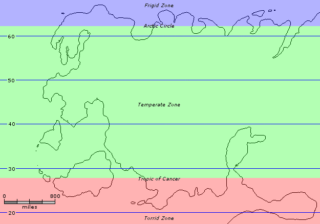
Geographical Zones
Prevailing Winds
I have assumed that the prevailing winds are the same on Dragaera as on Earth; that is, warm air around 30 degrees north moves towards the equator (curving to the west due to the Coriolis force), and to about 60 degrees north (while curving to the east). Cold air at the pole moves toward 60 degrees north while curving to the west:
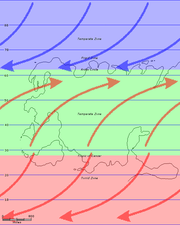
Prevailing Winds
Note that the actual direction of the wind at any given location will depend on a number of other factors, including the nearby terrain, and will vary from day to day and even hour to hour depending on local weather conditions.
Seasons
We are often given dates in the form "Early Spring" or "Late Winter." Using the 1st day of summer as a base point:
The ground was broken on the new Imperial Palace at a ceremony held on the first day of summer: the fifth day of the month of the Hawk.
I calculated the 1st day of each season as follows:
| Event | Day of the Year | Full Date |
| 1st Day of Spring | 1st | 1st day of the month of the Phoenix |
| 1st Day of Summer | 73rd | 5th day of the month of the Hawk |
| 1st Day of Fall | 145th | 9th day of the month of the Vallista |
| 1st Day of Winter | 217th | 13th day of the month of the Yendi |
From this, I was able to extrapolate the mid-point of each segment of each season as follows:
| Event | Day of the Year | Full Date |
| Early Spring | 13th | 13th day of the month of the Phoenix |
| Spring | 37th | 3rd day of the month of the Lyorn |
| Late Spring | 61st | 10th day of the month of the Tiassa |
| Early Summer | 85th | 17th day of the month of the Hawk |
| Summer | 109th | 7th day of the month of the Issola |
| Late Summer | 133rd | 14th day of the month of the Tsalmoth |
| Early Fall | 157th | 4th day of the month of the Jhereg |
| Fall | 181st | 11th day of the month of the Iorich |
| Late Fall | 205th | 1st day of the month of the Yendi |
| Early Winter | 229th | 8th day of the month of the Orca |
| Winter | 253rd | 15th day of the month of the Teckla |
| Late Winter | 277th | 5th day of the month of the Athyra |
In other words, if a date is given as "early spring", and there is nothing more accurate to go on, I will translate that date as the 13th day of the year when calculating travel times and the like.
Directions
Where possible, I have treated all directions as exact. That is, "north" means "due north".
However, most places that are referenced more than once do not fit neatly within such narrow definitions, so where needed, I have broadened my definitions of directions as follows:
North means more N than E or W. That is, +/- 45 degrees of due N.
Northeast means more NE than N or E, or +/- 22.5 degrees of due NE.
North by Northeast means more NNE than N or NE, or +/- 11.25 degrees of due NNE.
North by East means more NbE than N or NNE, or +/- 5.625 degrees of due NbE.
Directly North means +/- 5.625 degrees of due North.
Here is a compass rose showing the relationship of all of these directions.
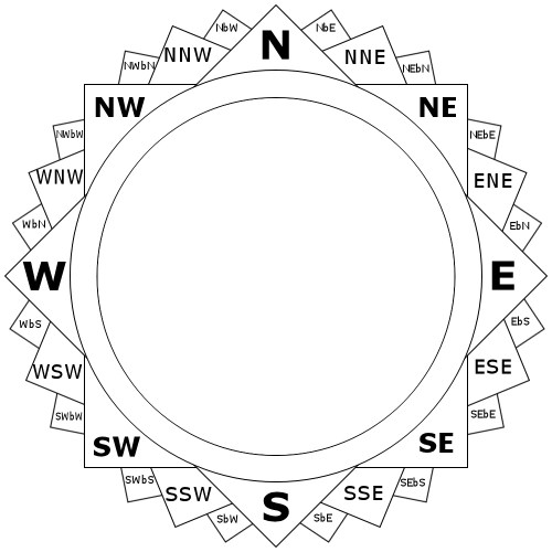
Compass Points
Distribution
There are a number of cases where a location is given as a range of possibilities, not as a single point. In such cases, I have assumed that the point is located in the center of the specified range.
For example, if a city were 300-400 miles from another point, I would assume it was about 350 miles as a starting point.
Similarly, if port B is along the coast between port A and port C, and I think I know where A and C are, I will assume B is midway between the two.
Descriptive Names
I have assumed that descriptive place names are accurate. That is, Southpoint is at the southern point of something, the Great Northwestern Road runs primarily to or in the northwest, the Yendi River twists and turns like a snake, and so forth.
Of course, I cannot rule out that there is a Dragaeran equivalent to Iceland or Greenland out there, but I think that assuming descriptive place names are accurate will help more than it will hinder this enterprise.
The Size of Mountains
Pel ... left Dzur Mountain, after which he made his way to a near-by posting house, some twenty or thirty miles away
we left [Pel] in a small village on the southern slopes of Dzur Mountain
Taken together, these two passages suggest that the slopes of Dzur Mountain extends at least 20-30 miles.
the House of the Dragon [had] dwellings not twenty leagues away, on the other side of the Broken Mountain
It appears that the Broken Mountain has a diameter of around 60 miles, or a radius of about 30 miles, which is very similar to Dzur Mountain.
they arrived in Kliuev, a small village nestled into what here were called the Mountains of Faerie, although only fifty or sixty miles to the west they were part of that great chain called the Eastern Mountains
While there is no indication that there is a single peak between the East and West here, this observation occurs toward the southern end of the Eastern Mountains, when the range is trailing off.
I think these three passages, taken together, suggest that mountains in Dragaera are, on average, between 25 and 30 miles in radius. I'm certain that every peak is unique, but when I have to estimate the size of a mountain (or the distance from its foothills to its peak), I will assume a radius of 25-30 miles.
The Distance Between Peaks
While the above works great for isolated mountains, or from the slopes of mountains to the peak, what about the distance between peaks in a mountain range?
I was unable to find much data on this subject for our planet. A master thesis titled "Landform identification from surface networks" looked at a subset of mountainous regions in Switzerland and found that
in the area under study, shown in Figure 4.10, the average distance between any two peaks in the ground truth data set results to be 44km
That's about 27 miles, which (perhaps coincidentally) is within the same radius as Steve appears to be using.
When there are mountain peaks that border each other, but specific distances between them are not given, I've assumed the peaks are about 25-30 miles apart.
In a few places, I have utilized a 25-mile hexagonal grid to help locate geographic features that are next to each other but whose precise distances are not given.
Miles in a League
Dragaerans and Easterners appear to measure leagues differently:
Sandyhome ... is hardly fifty leagues [from Pepperfields] ... we are bound for Redface, less than fifty leagues from Pepperfields. / Fifty leagues of the city, or fifty leagues by the Easterner's reckoning? / A day's brisk march by the footpaths ... or else two days' quick ride by the horse-paths.
And Dragaerans have at least two types of leagues in use:
A league in the Sorannah is almost two leagues within the ancient confines of Seawall, that is, within the barony that once held the city of Dragaera
Another example of different leagues is this claim:
the village of Newmarket, some sixty leagues from Dragaera City
On Steve's Map, Newmarket is 1,033 miles from Dragaera City, so this type of league would be equal to about 17 miles.
Finally, as I'll discuss later in the chapter on Newmarket (please see that chapter for full details), Lars claims they've been traveling at 5 leagues a day, and at the point he says this, they appear to have traveled about 650 miles in 15 days or so, which works out to 43 miles a day, which would make Lars' leagues equal to about 9 miles each.
Unless explicitly stated otherwise, I have assumed there are 3 miles per league (the same way we measure statute leagues).
Measuring Distance by Time
Sometimes the distance between two points is stated in hours or days rather than miles or leagues.
The first consideration that must be made is how to relate hours to days when it comes to traveling. I have assumed that no more than 18 hours a day will be spent traveling in most cases, based on this passage:
The naive observer might believe that Morrolan, Teldra, and Arra would, in fact, slow down upon procuring mounts ... instead of traveling ten or twelve hours a day, as they had been accustomed to do, they now began, without anyone making a decision to do so, to make stages of eighteen or nineteen hours a day, with the result that, though at no time did they consider themselves to be in a hurry, nevertheless they significantly increased the pace at which they made their way toward [Southmoor].
Here are all the references I could find to how many miles one might travel in a day. I have ignored as atypical those travel times made via the post system, as they appear to be much, much faster than any other form of travel short of teleportation.
| Distance | Time | Miles/Day | Source |
| 30 leagues 90 miles |
30 hours 30/18 days |
54 |
the distance from the Gate of the Darr to Ripple Point is scarcely a league, while it is a good thirty leagues from the Gate of Iron to Fosson's Well, yet, because the latter is over level ground with a good road laid on it, while the former is nearly straight up a mountainside covered in loose and crumbling rock, we may in justice assert that each of these places lies the same distance from the heart of Dragaera City, that distance being about thirty hours, or a full day and night.
|
| 40-45 miles | 1 day | 42.5 |
The distance from [the future home of Castle Black] to Dzur Mountain was not long--only some forty or forty-five miles How far is Castle Black from here [Dzur Mountain]? A day's ride.
|
| 15 leagues 45 miles |
10 or 11 hours 10.5/18 days |
77 |
there are the ruins of [a floating] castle nearby [from Bellows] Perhaps sixty or seventy miles west of here ... Then let us go there ... ten or eleven hours after setting out, they had traveled some fifteen leagues, bringing them, at the end of that time, to the wall that circled the village of Nacine, on the Hightower Brook
|
| 65-70 leagues 195-210 miles |
8 days | 25.3 |
Dzur Mountain, a distance of some sixty-five or seventy leagues [from Adrilankha]. [Zerika's journey from Adrilankha to Dzur Mountain] took us only eight days! / That _is_ good time!
|
| 2.5 leagues 7.5 miles |
2 hours 2/18 days |
67.5 |
take the road to the west [from Six Horses], in half a league, you will come to an elbow. Continue there as if there were no bend, and you will find a small path. When you reach a stream, follow it to the left for two leagues, and you will come to a cottage built into the side of the mountain [Tsira's home] ... they mounted their horses and, following the directions... found themselves, two hours later, looking at a small cottage next to a brook and surrounded by siju trees.
|
| 20-25 leagues 60-75 miles |
1 day | 67.5 |
[From the Pepperfields back to Dragaera City] they made stages of twenty or twenty-five leagues across the pushta, sometimes not stopping until full dark had fallen ... before many days had passed they found themselves once more in sight of Beed'n's Inn
|
The average travel time is 51.97 miles per day, and the median travel time is 54.0; for convenience, I rounded these figures to 50.
When distance is stated as a function of time, and there is no more specific way of determining the actual distance, I have assumed that the average traveler goes 50 miles in a day and 3 miles in an hour.
home | contents | previous | next | index
Questions? Comments? Please contact me at dragaera [at] bryann.net.
Copyright © 2020 Bryan Newell, unless otherwise noted.