home | contents | previous | next | index
Chapter 30 - The Lay of the Land
Steve's Map includes the following:
Everything else is just "land."
The Map of the East in Brokedown Palace contains more detail, including plains, marshes, hills and the Wandering Forest.
The text contains many references to terrain, but for the most part, not in a way that's easy to translate to a map. For example:
[from Adrilankha to Dzur Mountain] in a day or two the terrain assumed a character of grasslands occasionally dotted with woods ... after several days, the woods became denser and more frequent, until soon they were traveling through what could only be described as deep forest ...they were able to see Dzur Mountain standing up against the northern sky.
At best, this tells us the terrain along their path, but it doesn't indicate how far it extends on either side of their path (and while I have generally assumed they are always traveling in straight lines, this is just the least-speculative approach--in all likelyhood, they are NOT traveling in a straight line).
A note about the mountains on these two maps
On Steve's Map, mountains are drawn as large, overlapping peaks, in an almost isometric view. The Eastern Mountains are 2 to 4 mountains wide, east-to-west. On the Map of the East in Brokedown Palace, mountains are drawn much smaller, and the Eastern Mountains are about 6 or 7 mountains wide, east-to-west.
I'm confident that I have scaled the Map of the East in Brokedown Palace correctly (it's hard to get it wrong with the River From Faerie's sharp southward turn), so I assume this difference is just a stylistic choice.
On Steve's Map, some of the named peaks (South Mountain and Tiren's Peak, for example) have arrows that point to specific mountains, so I think the mountains on his map are supposed to be representative of the underlying terrain. The only significant change I made to them is that I redrew them from a top-down perspective.
Rocky Central District
At the scale I'm creating the map at, rivers flow downhill, which means they have a source above sea level. I think we can use this to make a few educated guesses:
I marked the source of the Eastern, Elbow and Brownclay Rivers as elevated.
The Grand Canal was cut through solid rock around Merwin:
... since the canal was built. The only significance of this barony ... had been the difficulty ... of cutting the canal through the solid rock of the district. It had required the combined effort of the Imperial engineers and the baron himself ... to dig the canal ... He had first intended to name the place Redrock, because the rock was, in fact, of a reddish color; but a distant cousin of his was already lord of a county far to the east called Redrocks; so, to avoid confusion, he named his home Sitria ...
And of course, two geologic features in Merwin are called Big Cliff and Small Cliff, so I marked the northern part of Merwin and the area directly to the north of the Canal as an elevated position.
Dragaera City appears to have been built on a plateau:
From the Gate of Flags our friends had traveled down the mountain to the small town of Everdim
I marked that area as elevated as well.
All of the rivers mentioned above (plus the Charis River) flow south, and all start in the central portion of the Empire. That plus the elevated areas along the Grand Canal suggests that the center of the continent is rocky and elevated.
To the north is the desert Suntra. Vlad describes the southern tip of the Suntra as "rocky and hard":
the country around Endra's is all rocky and hard and pretty in the same way the southern tip of Suntra is pretty--unforgiving but attractive, anyway.
It borders a valley (which suggests it's at a higher elevation than the valley):
There is a tree that grows between the Adrilankha River valley and the desert of Suntra
and is famous for its Steam Caves in the northern part:
the Steam Caves of Northern Suntra.
My guess is this central, elevated, rocky area extends as far north as the Suntra, which makes Suntra more similar to the Gobi desert than the Sahara desert.
River Basins
I generally assumed that land between rivers and bodies of water was elevated a little bit.
Here is an exaggerated view of what I think the drainage basins look like on Dragaera:
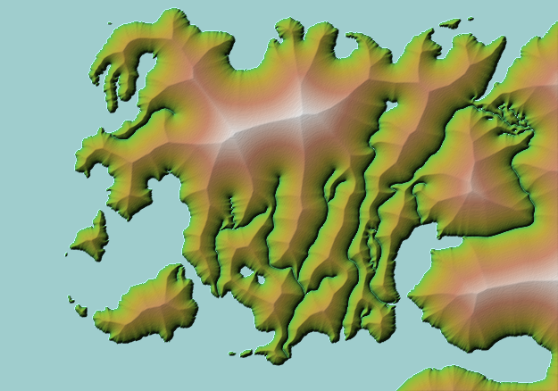
Drainage Basins
Note I excluded the Grand and Guinchen Canals and both Seas of Chaos since they are artificial.
home | contents | previous | next | index
Questions? Comments? Please contact me at dragaera [at] bryann.net.
Copyright © 2020 Bryan Newell, unless otherwise noted.